Saturday, December 29, 2007

Ghost town - Bodie, California

Bodie ghost town on the eastern slope of the Sierra Nevada mountain range in Mono County, California, United States, about 75 miles (120 km) southeast of Lake Tahoe, at an elevation of 8369 feet (2550 m).

Gold was discovered in 1859 by prospector Wakeman S. Bodey, who the town was named after. Bodey died in November making a supply trip and becoming stranded in a blizzard.

In 1876, the Standard Company discovered a profitable deposit of gold transformed Bodie from an isolated mining camp of few prospectors to a boomtown.

Bodie was famous for its lawlessness. At its peak in 1880, it had 60 saloons. Murders, brawls, and stagecoach holdups were constant occurrences. Legend has it that a little girl, upon finding out that her family was moving there,prayed one night, "Goodbye God, I am going to Bodie."

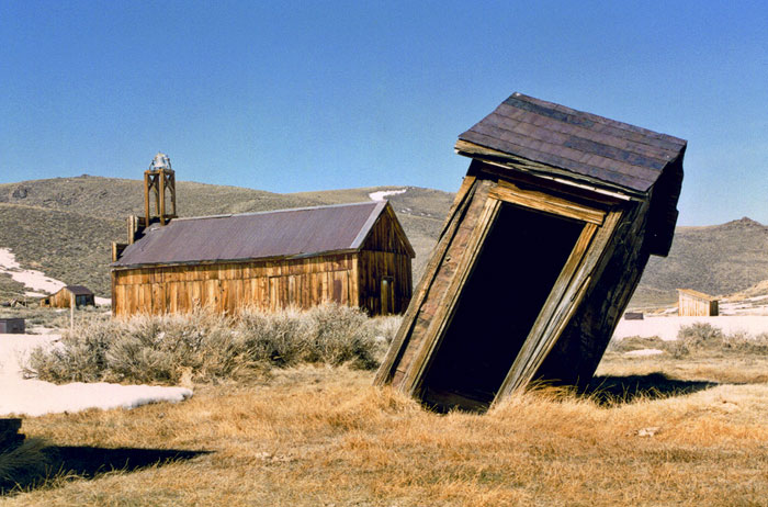
Gold bullion from the town's nine stamp mills was shipped to Carson City, Nevada accompanied by armed guards. Once the bullion reached Carson City, it was sent by rail to the San Francisco mint.

In 1893 the Standard Company built its own hydroelectric plant, located approximately 13 miles away on Green Creek, above Bridgeport, California. The plant developed a maximum of 130 horsepower and 6,600 volts alternating current to power the company's 20-stamp mill. This pioneering installation was one of the first times an electric motor was operated over long-distance power lines.

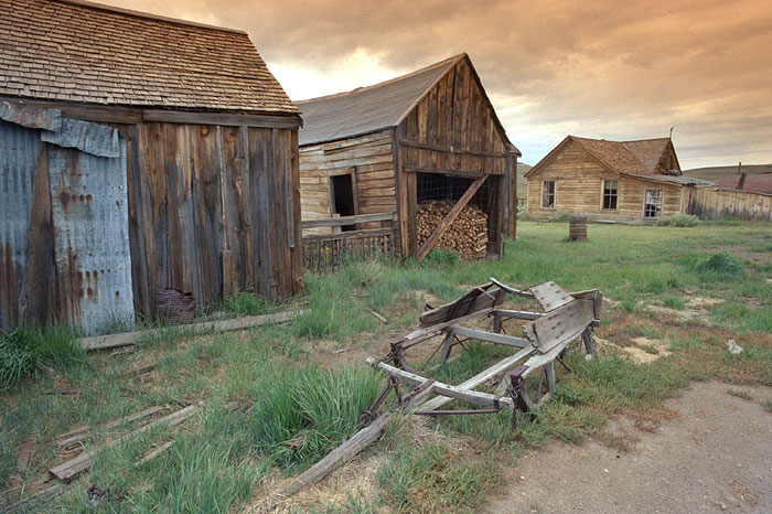
Bodie's Chinatown, had several hundred Chinese residents at one point. The Chinese workers earned their incomes mainly from selling vegetables, operating laundries, and cutting, hauling, and selling firewood. Winter temperatures in Bodie would often fall well below zero, and winds reaching nearly 100 miles per hour would sweep across the high open valley. Large amounts of firewood were needed to keep residents warm through the long winters. Many ill-prepared towns folk perished during the extremely harsh winter of 1878-1879.

Today Bodie is an authentic, intact ghost town. Bodie is currently a State Historic Park. Visitors walk the deserted streets of a town that once had a population between 7,000 and 8,000 people. Interiors remain as they were left and in some cases stocked with goods. The remains of Bodie are being preserved in a state of arrested decay...

Tuesday, December 25, 2007

Beaches in Southern Africa

Sun, sand, sea, skimpy swimsuits and the smell of coconut scented sun tan lotion. South Africa has a 3,000km coastline with thousands of beaches, some of which are more appealing than others. So if you’re after a beach holiday, you just need to decide what kind, and then choose the right beach.

The West Coast has some unbelievably beautiful, long, lonely beaches, where you can walk for miles and not see another person. Some lovely little towns, which were once fishing villages, are great to explore and also usually have nice beaches that are not quite so deserted, but also not that crowded. It hardly ever rains, so the West Coast is a good place to work on your sun tan but – be warned – the water is freezing. Probably the best West Coast destinations are Langebaan, Paternoster and, for surfers especially, Elands Bay.

Cape Town, of course, is a beach destination of note, where you’ll find a beach for every reason. The Southern Cape Coast refers to the whole section of coast between the eastern side of False Bay and somewhere near Mossel Bay, including the Overberg beaches. Settlements are few and far between and pretty laid back generally. They’re not nearly as crowded as Cape Town or the Garden Route, but not as deserted as the West Coast. Some of the favourite beach towns here include Arniston and Stilbaai.

The relatively understated resort towns of Gouritzmond and Boggomsbaai are close to Mossel Bay, and part of the wonderful Oyster Catcher Trail, which is a lovely guided, portered, catered hike, but they’re closer to the Southern Cape coast in feel.

Many people believe the western end of the Garden Route to be at Mossel Bay, which has the only north-facing beaches in South Africa by virtue of the deeply indented bay. Other great Garden Route beach destinations include Plett, Wilderness and the fabulous Nature’s Valley where the beach is almost deserted, and you can walk for miles to lovely streams where otters play. The Garden Route has great coastal hikes and it’s a great place to ride a horse on the beach.

The East Coast cities of Port Elizabeth and East London are also good beach holiday destinations but the Wild Coast, just that bit further east, is fabulous. The beaches are uncrowded, there are lovely little family-friendly hotels and there is awesome beach hiking and horse trails.

The epitome of organised beach frivolity, though, is found on the KZN South and North Coasts, where holiday developments stretch out almost continuously along the beach, and the water is warm. Durban’s beaches are a cultural experience where you will find a truly representative cross-section of South Africa’s population – from nubile bikini-clad teenagers and bronzed surfers strutting their stuff to elegant sari-clad matrons herding their broods and beaded sangomas collecting sea water for medicinal use. Even outdoor baptisms are not uncommon.

The beaches of the Greater St Lucia Wetland Park are, on the other hand, mostly much quieter. Here you can walk for miles, seeing only the odd fisherman, go snorkelling or just find a place to chill in the sun.

North of South Africa’s borders Mozambique, on the east coast, has hundreds of beautiful tropical paradise beaches while Namibia, on the west coast, does have a few good beaches but the water is icy and usually pretty rough. Most beach activity in Namibia is fishing-related.

Whichever beach experience you choose, be it sardine-style and social, or solitary and silent, bear in mind a few important precautions. Always use sunscreen and a hat. Be very careful of deserted beaches – most South Africans are very nice but some are very nasty, indeed.

Be aware of your limits in all things – how far you can swim, how long you can stay in the sun, and how much you can drink before you get the first two completely wrong and end up in deep trouble. Oh – as for the last one – it is illegal to drink on South African beaches, a law which is being relatively strictly enforced with blind eyes only occasionally turned towards quiet sundowners at sundown time.

Sunday, December 23, 2007

Megastructures - Millau Viaduct - France

World's Tallest Bridge

When it opened on 17 December 2004, the spectacular Millau Viaduct set new standards in both planning design and construction - without mentioning the record it set as the largest cable-stayed bridge in Europe.

At 2.4km long, and 270m above the river at its highest point, the Millau viaduct spans a 2km valley in the Massif Central mountain range and forms the final link in the A75 highway from Paris to Barcelona. Despite its huge length, journey time over the structure is expected to be just one minute.

The road has two lanes in each direction and cost €400 million. This will be recouped by the builder, Eiffage, under a 75-year concession.

Bridge design

Two major challenges were identified in building the structure: crossing the River Tarn, and spanning the huge gap from one plateau to the other. The solution proposed is unique, using seven pylons instead of the typical two or three. It is several metres taller than that other famous French landmark, the Eiffel Tower.

Famous British architect Norman Foster was in charge of the viaduct's appearance. It has been designed to look as delicate and transparent as possible. Each of its sections spans 342m and its columns range in height from 75m to 235m over the river Tarn. It uses the minimum amount of material, which made it less costly to construct: the deck, the masts rising above the road deck and the multi-span cables are all in steel.

Seven Piers

The seven piers of the Millau Viaduct are sunk in shafts of reinforced concrete in a pyramidal shape, being divided in an overturned V, and the shrouds are anchored and distributed in semi harps. The program utilised hundreds of high-pressure hydraulic cylinders and pumps to push-launch the deck spans in place and a PC-synchronised lifting system to lift the auxiliary piers. Enerpac was awarded the major contract to supply the hydraulic system for lifting and pushing the bridge spans and piers for the bridge.

Intriguingly, the Millau Viaduct is not straight. A straight road could induce a sensation of floating for drivers, which a slight curve remedies. The curve is 20km in range. Moreover, the road has a light incline of 3% to improve the visibility and reassure the driver.

Bridge Construction

Construction began in October 2001, and by November the following year, the highest pier had already reached 100m in height. Launching the deck started in February 2003, and was completed by May 2004.

Unusually, the deck is constructed from a new high-grade steel as opposed to concrete. This helped the deck to be pre-constructed in 2,000 pieces at Eiffage's Alsace factory and GPS-aligned, 60cm at a time.

The Millau Viaduct is supported by multi-span cables placed in the middle. To accommodate the expansion and contraction of the concrete deck, there is 1m of empty space at its extremities and each column is split into two thinner, more flexible columns below the roadway, forming an A-frame above the deck level.

Construction work used approx. 127,000m³ of concrete, 19,000t of steel-reinforced concrete and 5,000t of pre-constraint steel (cables and shrouds). The project needed 205,000t of concrete, of which 50,000m³ will be reinforced concrete. In total, the viaduct weighs 290,000t.

A 3m-wide emergency lane provides increased security. It will, in particular, prevent drivers from seeing the valley from the viaduct.

As the bridge will be exposed to winds of up to 151km/hr, side screens are used to reduce the effects of the wind by 50%. The speed of the wind at the level of the road therefore reflects the speed of the wind found at ground level around Larzac and Sauveterre.

Toll Station

An 18-lane toll station 6km north of the Millau Viaduct is housed under a structure made of a special concrete patented by the group Eiffage. The toll plaza includes a CCTV connection to the viaduct and the highway. It also accommodates technical and administrative services.

Saturday, December 22, 2007

Megastructures - The Akashi - Kaikyo Suspension Bridge

The Akashi Kaikyo Suspension Bridge is the longest suspension bridge in the world and it is probably Japan’s greatest engineering feat.

It took two million workers ten years to construct the bridge, 181 000 tonnes of steel and 1.4million cubic metres of concrete. The steel cable used would circle the world seven times.

It has six lanes and links the island of Awaji and the mainland city of Kobe, a distance of four miles. The concept of building a bridge across the Akashi Straits became urgent after a disaster in 1955. A ferry carrying over one hundred children sank after colliding with another ferry, in the busy shipping lane. One hundred and sixty eight children and adults died in the disaster. Political pressure for a bridge increased and in 1988 construction began.

The Akashi Straits is four miles wide at the bridge site with sea depths of one hundred metres and currents averaging fourteen kmph. The Akashi Straits is one of the busiest sea lanes in the world with over a thousand ships per day travelling through it. Furthermore, the bridge is in a typhoon region in which winds can reach speeds of 290 kmph.

The construction of a suspension bridge involves the use of two main cables stretching between two towers. The roadway beneath these is suspended by more cables. To stop the towers, roadway and cables collapsing, they are held at either end by large anchor blocks (the Akashi anchor blocks weigh 350 000 tonnes). In the case of the Akashi-Kaikyo Bridge, suspension bridge technology was pushed to the limit.

The Japanese designers and engineers tested their designs by building complex models. These were tested in wind tunnels which helped them refine the design so that the bridge could cope with severe weather and typhoon conditions. The photograph opposite shows 40 metre long model, set up for a variety of scientific tests.

After vigorous testing had taken place, construction of the real bridge could begin.


The two towers stand on two large circular foundations. The moulds for the two foundations were built in dry dock weighing 15 000 tonnes and 60 metres in height. In March 1989 a major stage of construction was reached with the moulds for the foundations to the towers being towed out to their positions in the sea by numerous tugs. When in position the moulds were flooded with two hundred and fifty million litres of water, taking eight hours to complete. By the time the moulds were full, they were resting on the sea bed.


Each of the two foundations were filled with 265 000 cubic metres of concrete. However, ordinary concrete does not mix with water and so the Japanese had to develop special concrete which was capable of mixing with sea water.

In 1989 work on the two towers began. Each is nearly as high as the Eiffel Tower and is designed to have a two hundred year lifespan. The towers are 283 metres in height and if the foundations are included, this adds a further 60 metres.
Each tower is made up of 90 sections and they were built with absolute precision as the design allowed only a 25mm offset at the top. In order to achieve this level of accuracy each of the blocks were ‘surface ground’ to a precise finish. 700 000 bolts were used to fix each of the towers together.
Each tower is designed to flex / move in storm force conditions. They and even have a special mechanism that counteracts and dampens movement.

When the towers were completed a temporary cable was stretched between both and a wire mesh gangway built so that workers could start construction of the main cables. This temporary gangway can be seen in the photograph to the right. Workers and machinery pulled the main cables from one tower to the other.

Once the main cables and the vertical cables were in position the deck / roadway was fixed hanging below them. This work took place in 1994. Large purpose built cranes were used to lift the sections, 4000 tonnes each, were bolted into position, one after another. 290 sections make up the entire bridge.
The photographs to the right show the cranes in operation and the deck as it was fixed in position, section by section.
Each section has a triangulated form. This means that weight is kept to a minimum and yet each section has maximum strength.

The final section of the deck was bolted in position in September 1998 and the bridge was opened to the public on the 5th of April of the same year.

Thursday, December 20, 2007

Living in Antarctica

Logistics and support for New Zealanders going to Antarctica are provided by Antarctica New Zealand. Although based in Christchurch, Antarctica New Zealand operates NZ's Scott Base, which is located on Ross Island in McMurdo Sound. The US base, McMurdo Station, is also on Ross Island, and members of the NZ and US programmes share flights to Antarctica. Anyone going to Antarctica must first pass a thorough medical and dental checkup.

Getting There

Travel to Antarctica is by either sea or air. Most people fly, and up to 5 flights a week may leave NZ from the International Antarctic Centre terminal in Christchurch each summer. Early in the season large cargo planes (Galaxies and Starlifters from the US) transport cargo and people to Antarctica. Planes land on a sea-ice runway but as the weather warms, the ice weakens and the big planes are replaced by smaller Hercules. When the sea-ice becomes too thin for the Hercules to land safely, a runway is made on the permanent ice of the Ross Ice Shelf. Special US Hercules equiped with skis then carry out all the flights between NZ and McMurdo.

The RNZAF (NZ airforce) flies wheeled Hercules. The journey to Antarctica in these planes is very exciting. They are quite old and noisy but are renowned for their cargo-carrying capacity and ability to take-off and land on short runways. A Hercules has 4 large engines and is able to land safely even if 3 of them fail!

Passengers must wear full survival clothing, so you can get quite hot during the 6 to 7 hr journey! The planes are not built for comfort; there is not much room, and passengers sit side-by-side in rows of webbing seats. It's hard to see out of the few tiny windows and there's only one basic toilet at the back.

Just past ?way is the point of no return; there's enough fuel to get to McMurdo Sound, but not back home! (Planes will quite often turn back before this point if conditions become unsuitable for landing in Antarctica.)

Scott Base

Situated at the southern end of Ross Island, Scott Base is right next door to the United States base, McMurdo Station. Consisting of a number of green-painted buildings linked by all-weather corridors, the building of the base first began in 1957. More buildings have been added over the years and now up to 100 people can be accommodated, along with the kitchen, workshops, laboratories, storerooms and other work spaces that support them. Each building is like a large fridge, except it keeps the cold out not in! It's a comfortable and friendly place with plenty to do, and all the mod cons of home. There is a shop, library, sauna, bar, and a social club that organizes special activities and functions including sporting (e.g. skiing) and cultural events. These facilities are especially important for the dozen or so hardy souls who over-winter through the dark months of June and July.

Each year Scott Base is the centre from which up to 70 different events are organized — not easy when one considers the logistics of coordinating personnel, travel, food, shelter, training, communication and safety in a harsh environment. In the 2001/02 summer, for example, a variety of research events on fish, glaciers, microbes, lichens and mosses, marine invertebrates, penguins, the dry valleys, climate, Antarctic soils, seals, ice, geomagnetism, algae and historic sites took place.

Antarctic Field Training

Before going into the field, all visitors to the ice must participate in a 2-day Antarctic Field Training (AFT) course. Qualified instructors take newcomers through the skills of assembling tents, building snow caves, mountain and ice travel, first aid, cooking, radios, survival bags, keeping warm and safe, etc.

It's a good feeling when the training and preparation are complete, and a research party with all their gear can leave for the study site.

Transport into the field

Depending on the weather, terrain and distance to be covered, several means of transport are possible.

  • Walking
  • Skiing
  • 4WD vehicle
  • Skidoo (snowmobile)
  • Argo (a smaller 8-wheeled amphibious vehicle)
  • Hagglund (a tracked vehicle that can carry up to 13 people)
  • Sledges (various sizes and designed to be towed behind another vehicle)
  • Twin Otter (a fixed-wing aircraft)
  • Helicopter

Life in the field

Scientists working at sites remote from Scott Base need to set up camp. There may be a permanent building (hut) at the site, or Scott Base may organise that a temporary building is towed to the site (wannigan). At sites where there are no buildings, scientists set up a tent camp.

Field Camp

Our reasearch is carried out at Cape Bird. Cape Bird is a narrow strip of stony coastline at the foot of Mt Bird in the NW corner of Ross Island. Here Antarctica NZ have built a comfortable 8-person hut that is in constant use by scientists over the summer months. The hut consists of 2 bunkrooms, a kitchen/dining room, pantry, storeroom and laboratory all kept warm by a diesel heater that never stops. Securely anchored down with wire ropes, the hut is designed to withstand the frequent blizzards and winds that sweep up the coast. The ever-changing view from the living room windows looks westwards across McMurdo Sound to the trans-Antarctic mountains in the distance.

Food

Along with shelter and warmth, having enough to eat and drink is the most important requirement for anyone working in Antarctic.

Special efforts are made to ensure that plentiful supplies of wholesome and, where possible, fresh foods are provided. Diets are not unlike what we'd expect at home and the quantity and variety may even be better; a big difference from the situation in the early days of Antarctic exploration! Today, several base stations even have their own hydroponically grown vegetables.

In summer, workers in the field can look forward to occasional helicopter deliveries of fresh vegetables, fruit and frozen meat. When tenting, food is cooked using small fuel burners; larger gas cookers are used in huts.

Water

Because it never rains in Antarctica, drinking water must be obtained either from the sea, (in which case the salt must be removed in an energy-consuming reverse-osmosis process), or by melting snow or ice. One of the chores in the field is the need to collect and melt snow for drinking, cooking and washing.

Grey water (so called because of the colour of the water after it has been used for washing and cleaning), is collected and retrograded (returned) to Scott Base for disposal.

Surprisingly, the dry conditions in Antarctica mean that fire is a real risk, and a reserve supply of water must also be kept for fire-fighting purposes.

Toilets

In larger, coastal, base stations, sewage is usually mascerated, filtered and then piped into the sea where it disperses and decomposes. In the field, body waste is collected and retrograded to Scott Base for disposal.

Communication

Living in an Antarctic field camp for any length of time can make scientists feel very isolated from the outside world. Radio links with other camps, base stations or home are a vital means of communication on the ice.

Both VHF (very high frequency) and HF (high frequency) battery-powered radios are used. Solar panels keep the batteries charged. VHF radios are used for line-of-sight communication over shorter distances. Repeater stations may be used when there is a physical obstruction like a mountain in the way! HF radios can be used to communicate with anyone else in the world. Signals are bounced off the ionosphere 50 to 100 km above the earth. Reception can be severely disrupted in times of sunspot activity however!

Monday, December 17, 2007

Current active volcanoes on Earth

Name of Volcano Location Status
AkanJapanGreen
AkutanAleutian Is.Green
AlaidKurile Is.Green
AmbrymS.pacificAlert Level 0
AnatahanMariana Is.Yellow
AniakchakAlaskaGreen
AobaVanuatuAlert Level 0
ApoyequeNicaraguaYellow
ArenalCosta RicaOrange
AsamaJapanGreen
AsoJapanGreen
Atka (Korovin)Aluetian Is.Green
AugustineAlaskaGreen
AvachinskyKamchatkaGreen
AwuSangihe Is.Alert Level 0
AzulGalapagos Is.Green
AzumaJapanGreen
BaganaPapua New GuineaAlert Level 1
BamusPapua New GuineaAlert Level 0
BandaiJapanGreen
Barren Is.Indian OceanGreen
Batu TaraIndonesiaAlert Level 0
BaturIndonesiaAlert Level 0
BezymiannyKamchatkaYellow
BulusanPhilippinesAlert Level 1
CameroonW. AfricaGreen
CeremeJavaAlert Level 0
Cerro NegroNicaraguaGreen
ChikurachkiKurile Is.Yellow
ClevelandAleutian Is.Yellow
ColimaMexicoYellow
ConcepcionNicaraguaYellow
CopahueChilieGreen
DabbahuEthiopiaGreen
DempoSumatraAlert Level 0
DiengJavaAlert Level 0
DukonoIndonesiaAlert Level 1
EbekoKurile Is.Green
EgmontNew ZealandAlert Level 0
EgonIndonesiaAlert Level 0
Erta AleEthiopiaYellow
FernandinaGalapagos Is.Green
FisherAleutian Is.Green
FourpeakedAlaskaGreen
FuegoGuatemalaOrange
GalerasColombiaLevel III
GalunggungJavaAlert Level 0
GamalamaHalmaheraAlert Level 0
GamkonoraHalmaheraAlert Level 1
GarbunaNew BritainAlert Level 1
GorelyKamchatkaGreen
Great SitkinAleutian Is.Green
Guagua PichinchaEcuadorGreen
GunturJavaGreen
Hachijo-JimaJapanGreen
HakoneJapanGreen
Heard Is.Indian OceanAlert Level 0
HeklaIcelandGreen
Home ReefTonga Is.Green
HuilaColombiaOrange
IjenJavaAlert Level 1
IliamnaAlaskaGreen
IliwerungIndonesiaAlert Level 0
InielikaInielikaAlert Level 0
IsanotskiAleutian Is.Green
Iwo JimaJapanGreen
Jebel al TairYemenOrange
Jebel al-TairYemenOrange
KabaSumatraGreen
KanlaonPhillipinesAlert Level 0
KaraiPapua New GuineaAlert Level 0
KarangetangSangihe Is.Alert Level 2
KarthalaIndian OceanYellow
KarymskyKamchatkaYellow
KavachiSolomon Is.Green
KelutJavaAlert Level 2
KerinciSumatraAlert Level 2
KikaiJapanGreen
KilaueaHawaiiOrange
KliuchevskoiKamchatkaGreen
KomagatakeJapanGreen
KrakatauIndonesiaAlert Level 2
La PalmaCanary Is.Green
LamingtonPapua New GuineaGreen
LangilaPapua New GuineaAlert Level 0
LascarChileGreen
LerebolengIndonesiaGreen
LewotobiIndonesiaAlert Level 0
LlaimaChileGreen
Lokon EmpungSulawesiAlert Level 3
LopeviS. PacificAlert Level 0
MageikAlaskaGreen
MakianHalmaheraGreen
MakushinAleutian Is.Green
ManamPapua New GuineaAlert Level 1
MarapiSumatraAlert Level 1
MaroaNew ZealandAlert Level 0
MartinAlaskaGreen
MasayaNicaraguaGreen
Mauna LoaHawaiiYellow
MayonPhilippinesAlert Level 1
McDonald IslandsIndian OceanGreen
MerapiJavaAlert Level 1
Miyake-JimaJapanGreen
Mt. BelindaSandwich Is.Green
Mt. ErebusAntarcticaOrange
Mt. EtnaSicilyOrange
Mt. FujiJapanGreen
Mt. SpurrAlaskaGreen
Mt. St. HelensUnited StatesOrange
MutnovskyKamchatkaGreen
Nevado Del RuizColombiaGreen
NgauruhoeNew ZealandAlert Level 1
NyamuragiraC. AfricaYellow
NyiragongoC. AfricaOrange
OkmokAleutian Is.Green
Ol Doinyo LengaiE. AfricaGreen
PacayaGuatemalaOrange
PaganMariana Is.Yellow
PagoNew BritainAlert Level 0
PapandayanJavaAlert Level 1
PavlofAlaskaGreen
Peuet SagueSumatraAlert Level 0
Piton dela FournaiseIndian OceanYellow
PoasCosta RicaGreen
PopocatepetlMexicoYellow
RabaulNew BritainAlert Level 2
Raoul Is.Kermedic Is.Alert Level 0
RaungJavaAlert Level 0
RedoubtAlaskaGreen
ReventadorEcuadorYellow
RinjaniIndonesiaAlert Level 0
Ritter Is.Papua New GuineaAlert Level 0
RuangSangihe Is.Alert Level 0
RuapehuNew ZealandAlert Level 1
Sakura-JimaJapanOrange
San CristobalNicaraguaGreen
San MiguelEl SalvadorGreen
SangayEcuadorYellow
Santa AnaEl SalvadorGreen
Santa MariaGuatemalaOrange
SemeruJavaAlert Level 1
SheveluchKamchatkaOrange
ShishaldinAleutian Is.Green
Sierra NegraGalapagos Is.Yellow
SlametJavaYellow
SoputanSulawesiAlert Level 2
Soufriere HillsWest IndiesAlert Level 4
StromboliItalyOrange
Suwanose-JimaJapanYellow
TaalPhilippinesAlert Level 1
TalangSumatraAlert Level 2
TanagaAluetian Is.Green
TandikatSumatraAlert Level 0
Tangkuban ParahuJavaAlert Level 0
TaupoNew ZealandAlert Level 0
TelicaNicaraguaGreen
Tengger (Bromo)JavaAlert Level 0
TokachiJapanGreen
TongkokoSulawesiAlert Level 0
TorishimaJapanGreen
TridentAlaskaGreen
TungurahuaEcuadorOrange
TurrialbaCosta RicaYellow
UbinasPeruOrange
UlawunNew BritainAlert Level 1
UsuJapanGreen
VeniaminofAlaskaGreen
VillarricaChileOrange
WestdahlAleutian Is.Green
White Is.New ZealandAlert Level 1
YasurSo. PacificAlert Level 3

Tuesday, December 11, 2007

The worst ice storm in Canadian History was in 1998?

While freezing rain is not an uncommon Canadian experience, the ice storm that hit eastern Ontario, Quebec, and New Brunswick was exceptional. Environment Canada senior climatologist and resident climate expert, David Phillips, provides us with his analysis of how Ice Storm'98 stacks up in the record books.

Ice storms are often winter's worst hazard. More slippery than snow, freezing rain or glaze is tough and tenacious, clinging to every object it touches. A little can be dangerous, a lot can be catastrophic.

Ice storms are a major hazard in all parts of Canada except the North, but are especially common from Ontario to Newfoundland. The severity of ice storms depends largely on the accumulation of ice, the duration of the event, and the location and extent of the area affected. Based on these criteria, Ice Storm'98 was the worst ever to hit Canada in recent memory. From January 5-10, 1998 the total water equivalent of precipitation, comprising mostly freezing rain and ice pellets and a bit of snow, exceeded 85 mm in Ottawa, 73 mm in Kingston, 108 in Cornwall and 100 mm in Montreal. Previous major ice storms in the region, notably December 1986 in Ottawa and February 1961 in Montreal, deposited between 30 and 40 mm of ice - about half the thickness from the 1998 storm event!

The extent of the area affected by the ice was enormous. Freezing precipitation is often described as "a line of" or "spotty occurrences of". At the peak of the storm, the area of freezing precipitation extended from Muskoka and Kitchener in Ontario through eastern Ontario, western Quebec and the Eastern Townships to the Fundy coasts of New Brunswick and Nova Scotia. In the United States, icing coated Northern New York and parts of New England.

What made the ice storm so unusual, though, was that it went on for so long. On average, Ottawa and Montreal receive freezing precipitation on 12 to 17 days a year. Each episode generally lasts for only a few hours at a time, for an annual average total between 45 to 65 hours. During Ice Storm'98, it did not rain continuously, however, the number of hours of freezing rain and drizzle was in excess of 80 - again nearly double the normal annual total.

Unlucky too! The storm brutalized one of the largest populated and urbanized areas of North America leaving more than four million people freezing in the dark for hours, if not, days. Without question, the storm directly affected more people than any previous weather event in Canadian history. Into the third week following the onset of the storm, more than 700,000 were still without electricity. Had the storm tracked 100 km farther east or west of its main target, the disruptive effect would have been far less crippling.

How did the storm affect Canada:

  • at least 25 deaths, many from hypothermia.

  • about 900,000 households without power in Quebec; 100,000 in Ontario.

  • about 100,000 people took refuge in shelters

  • residents were urged to boil water for 24 to 48 hours.

  • airlines and railway discouraged travel into the area

  • 14,000 troops (including 2,300 reservists) deployed to help with clean up, evacuation and security.

  • millions of residents forced into mobile living, visiting family to shower and share a meal or moving in temporarily with a friend or into a shelter.

  • prolonged freezing rain brought down millions of trees, 120,000 km of power lines and telephone cables, 130 major transmission towers each worth $100,000 and about 30,000 wooden utility poles costing $3000 each.

The damage in eastern Ontario and southern Quebec was so severe that major rebuilding, not repairing, of the electrical grid had to be undertaken. What it took human beings a half century to construct took nature a matter of hours to knock down.

Farmers were especially hard hit. Dairy and hog farmers were left without power, frantically sharing generators to run milking machines and to care for new-born piglets. Many Quebec maple syrup producers, who account for 70% of the world supply, were ruined with much of their sugar bush permanently destroyed.

Unprecedented View Of Mysterious 'Night-shining' Clouds

NASA's AIM satellite has provided the first global-scale, full-season view of iridescent polar clouds that form 50 miles above Earth’s surface.

The Aeronomy of Ice in the Mesosphere (AIM) mission is the first satellite dedicated to the study of these noctilucent or "night-shining" clouds. They are called "night shining" clouds by observers on the ground because their high altitude allows them to continue reflecting sunlight after the sun has set below the horizon. AIM has provided the first global-scale view of the clouds over the entire 2007 Northern Hemisphere season with an unprecedented horizontal resolution of 3 miles by 3 miles.

Very little is known about these 'clouds at the edge of space', also called Polar Mesospheric Clouds. How do they form over the summer poles, why are they being seen at lower latitudes than ever before, and why have they been growing brighter and more frequent? During its mission lifetime, AIM will observe a total of two complete polar mesospheric cloud seasons in each polar region, documenting for the first time the entire complex life cycle of Polar Mesospheric Clouds.

"The AIM mission has changed our view of Polar Mesospheric Clouds and their surroundings after only one season of observations," stated AIM Principal Investigator James Russell III of Hampton University, Hampton, Va. "The measurements show the brightest clouds ever observed with more variability and structure than expected, signifying extreme sensitivity to the environment in which the clouds form. They also show that the clouds exist over a broader range in height than was believed to be the case before AIM was launched. The unprecedented sensitivity has revealed for the first time the presence of very small ice particles believed to be responsible for the mysterious radar phenomenon known as "Polar Mesospheric Summertime Echoes".

The bright "night-shining" clouds were seen by the spacecraft's instruments regularly, first appearing on May 25 and lasting until August 25.

The AIM satellite reported daily observations of the clouds at all longitudes and over a broad latitude range extending from 60 degrees North to 85 degrees North. The AIM satellite is currently making the first global observations of the Southern Hemisphere cloud season. The clouds consist of ice crystals formed when water vapor condenses onto dust particles in these coldest regions of our planet, at temperatures that may dip to minus 210 to minus 235 degrees Fahrenheit.

New results from AIM's first Northern Hemisphere season observations show:

1. The most detailed picture of the clouds ever collected showing that they appear every day, they are widespread, and they are highly variable on hourly to daily time scales.

2. That Polar Mesospheric Cloud brightness varies over horizontal scales of about two miles; and over small regions, clouds measured by AIM are ten-fold brighter than measured by previous space-based instruments.

3. The unexpected result that mesospheric ice occurs in one continuous layer extending from below the main peak at 51 miles up to around 55 miles.

4. Observations of a previously suspected, but never before seen, population of very small ice particles believed to be responsible for strong radar echoes from the summertime mesosphere. This was made possible because of the unprecedented sensitivity of the AIM measurements.

5. Polar Mesospheric Cloud structures resolved for the first time that exhibit complex features present in normal tropospheric clouds. This startling similarity suggests that the mesosphere may share some of the same dynamical processes responsible for weather near the surface. If this similarity holds up in further analysis, this opens up an entirely different view of potential mechanisms that can explain why the clouds form and how they vary.

The new results were produced by David Rusch and the Cloud Imaging and Particle Size experiment team, University of Colorado, Laboratory for Atmospheric and Space physics (result 1, 2 and 5); and Larry Gordley and Mark Hervig and the Solar Occultation for Ice Experiment team, Gats, Inc., Newport News, Va. (results 3 and 4).

AIM is a NASA-funded Small Explorers mission managed by the Explorers Program Office at Goddard Space Flight Center, Greenbelt, Md.

credited by ScienceDaily LLC

World's Most Dangerous Animals

Deadliest animals in the world ranked by estimated number of human fatalities per year:

1. Mosquito over 2 million deaths per year resulting from malaria infection caused by mosquito bites.
The mosquito is a member of the family Culicidae; these insects have a pair of scaled wings, a pair of halteres, a slender body, and long legs. The females of most mosquito species suck blood from other animals.


2. Snake over 100,000 deaths per year.
Snakes , also known as ophidians, are cold-blooded legless reptiles closely related to lizards, which share the order Squamata. There are also several species of legless lizard which superficially resemble snakes, but are not otherwise related to them.

3. Scorpion up to 5,000 deaths per year.
A scorpion is an invertebrate animal with eight legs, belonging to the order Scorpiones in the class Arachnida.


4. Crocodile up to 2,000 deaths per year.
A crocodile is any species belonging to the family Crocodylidae . The term can also be used more loosely to include all members of the order Crocodilia: i.e. the true crocodiles, the alligators and caimans and the gharials . The crocodiles, colloquially called crocs, are large aquatic reptiles that live throughout the Tropics in Africa, Asia, the Americas and Australia.

5. Elephant over 600 deaths per year.
Elephantidae is a family of pachyderm, and the only remaining family in the order Proboscidea in the class Mammalia. Elephantidae has three living species: the African Bush Elephant and the African Forest Elephant and the Asian Elephant .


6. Bee over 400 deaths per year.
Bees are flying insects, closely related to wasps and ants. There are approximately 20,000 species of bees, and they may be found on every continent except Antarctica. Bees are adapted for feeding on nectar and pollen, the former primarily as an energy source, and the latter primarily for protein and other nutrients.


7. Lion over 250 deaths per year.
The lion is a mammal of the family Felidae and one of four "big cats" in the genus Panthera. The lion is the second largest cat, after the tiger. The male lion, easily recognized by his mane, weighs between 150-225 kg and females range 120-150 kg . In the wild, lions live for around 10–14 years, while in captivity they can live over 20 years.

8. Hippopotamus over 200 deaths per year.
The Hippopotamus , from the Greek ?pp?p?ta?? , is a large, plant-eating African mammal, one of only two extant, and three or four recently extinct, species in the family Hippopotamidae.


9. Jellyfish over 100 deaths per year.
Jellyfish are marine invertebrates belonging to the Scyphozoan class, and in turn the phylum Cnidaria. The body of an adult jellyfish is composed of a bell-shaped, jellylike substance enclosing its internal structure, from which the creature's tentacles suspend.


10. Shark 30 -100 deaths per year.
Sharks are fish with a full cartilaginous skeleton and a streamlined body. They respire with the use of five to seven gill slits. Sharks have a covering of dermal denticles to protect their skin from damage, parasites and to improve fluid dynamics.

Sunday, December 2, 2007

World's weirdest skycraper structures

Koning Keizer Admiraal Transmission Mast
101.2 m
- This was the tallest tower ever built for an illegal radio station. The tower was dismantled in soon after its construction in 2004.


BREN Tower
465.5 m
- This guyed mast tower is used for scientic test research, primarily to measure raditation levels at different heights above the ground.
- This tower was originally erected at Yuca Flat - Area 4 at the Nevada Test Site in 1962.


Funkturm
150.0 m
- World's only observation tower standing on insulators (however these insulators were never in use. It was planned to insulate Funkturm Berlin, which carried until 1935 together with an 80 metre tall guyed mast an antnna for medium wave against ground for embettering the effiency of he antenna, however this was cancelled in order not to endanger the visitors of the tower and so it was grounded over the elevator shaft)

Fallturm UNI Bremen
146.0 m
- This drop tower is used for conducting scientific experiments concerning weightlessness.


Express Lift Tower
127.5 m
-The only elevator testing tower to have been built in the United Kingdom.