Wednesday, April 30, 2008

Dades Valley - Morocco

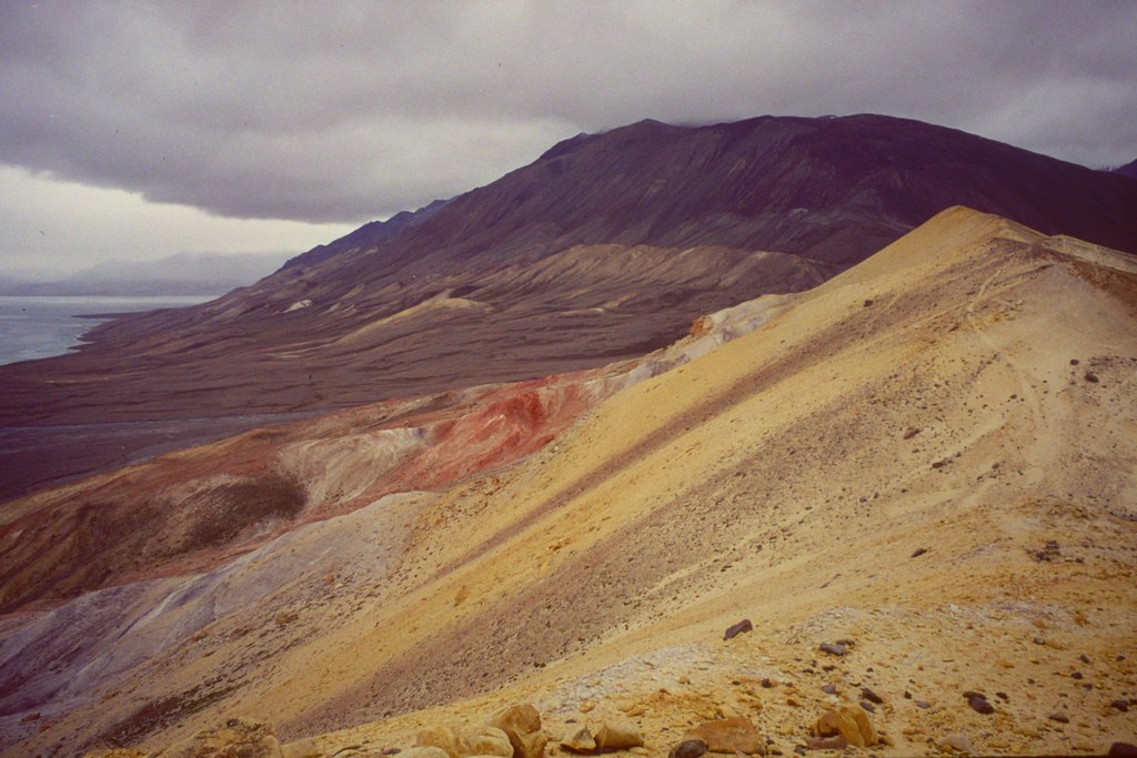
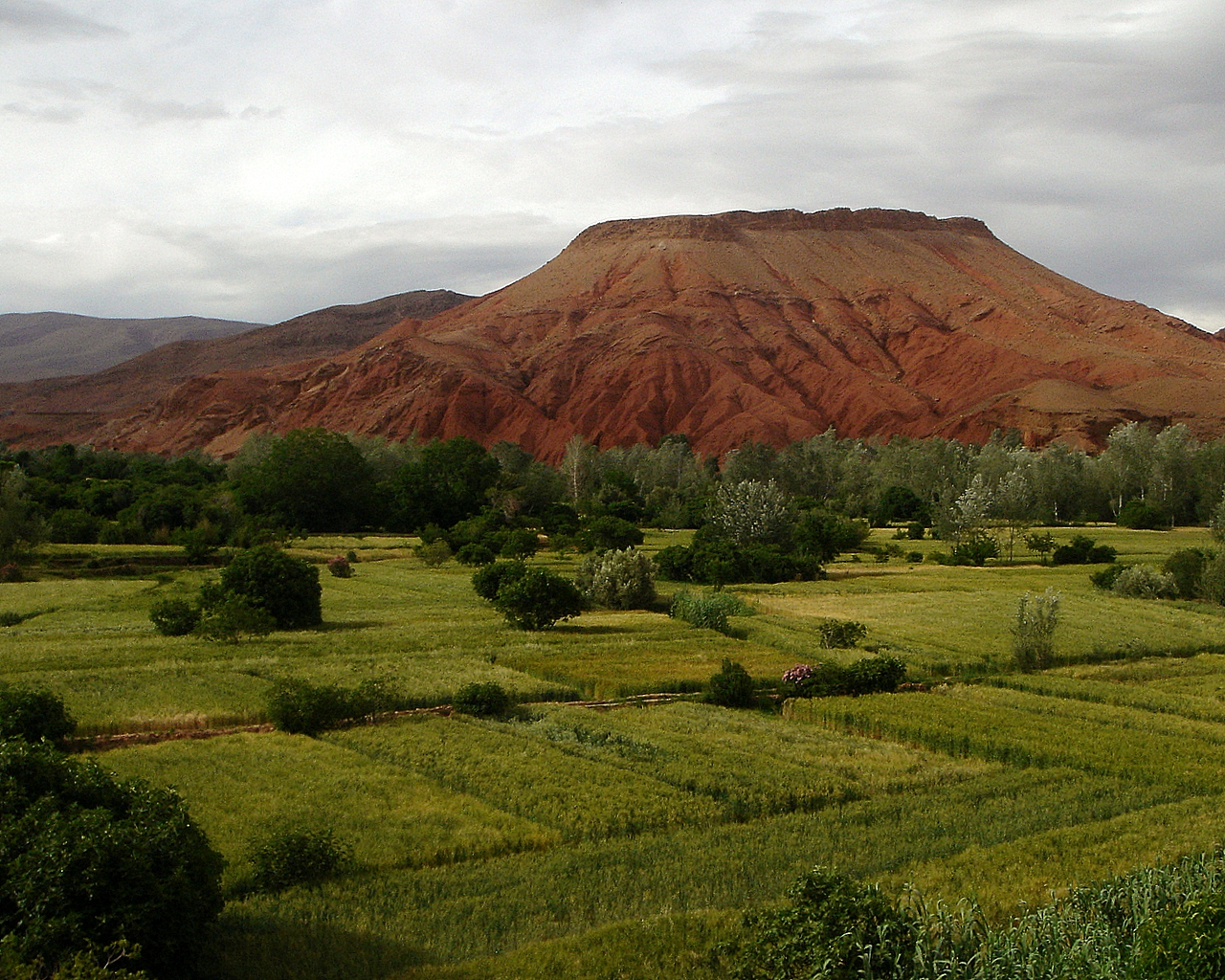
The strength of the colours will never escape your memory, red, green and white. The Dades Gorge has a fairy-tale feeling — just after you leave the rather dull Boumalne du Dades, the mountain closes up on both sides of you, before it opens again and you are in a world where the grass is greener, the soil redder and houses nicer.

Serpentine roads leads you slowly through community after community, villages set apart by dramatic twirls in the mountains, or by the fresh river meandering through the middle. Perhaps there still are blood feuds between the villages, legendary romances across hostile clans, rivalries that fills a life time? Your imagination is fed by the marvelous nature that unfolds while you carefully make sure that you do not drive off the road. But, from what everyone tells you, it is all calm now.

The drive through the Dades Valley will not lead you to any landmarks, but there is a mind-bending drama in catching how life conditions change quickly as you and your vehicle slowly rise in altitude, and as the valley gets more and more narrow.

It is clear that the most dramatic part of the Dades Valley is along the normal road before you reach Aït Oudinar. Some places the mountains turn and twist into formations not seen many other places, but even better is it that the intense red colour does not fade.

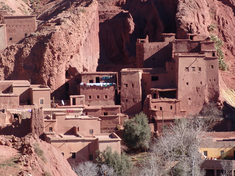
It is important to stop and walk close to the settlements along the Dades Valley. While the shifting of the landscape could intrigue for a whole day of slow driving up and back, colours become even stronger once you stand in a garden or in front of one of the houses.

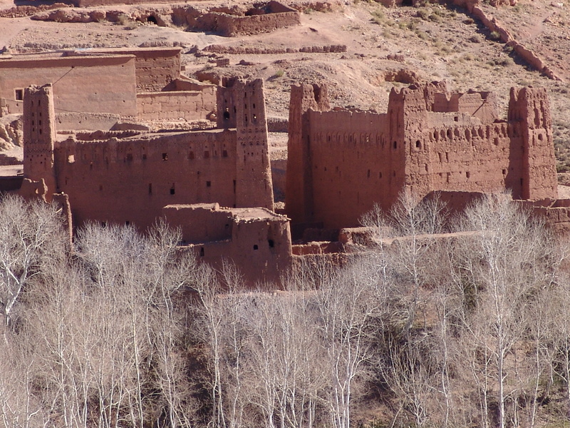
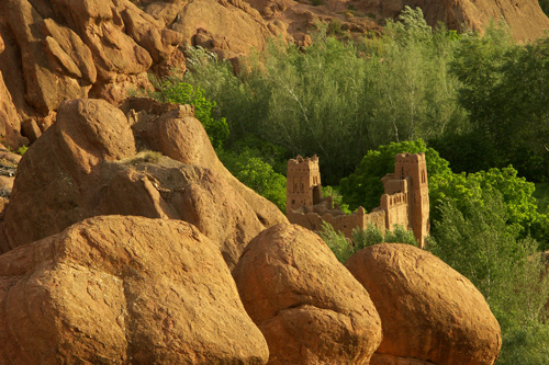
As one of several fortified ksours along the road, the one of Aït Youl is among the largest.

Protected by the mountains, and protecting the fertile fields along the river, it was naturally turned into a fortified dwelling.

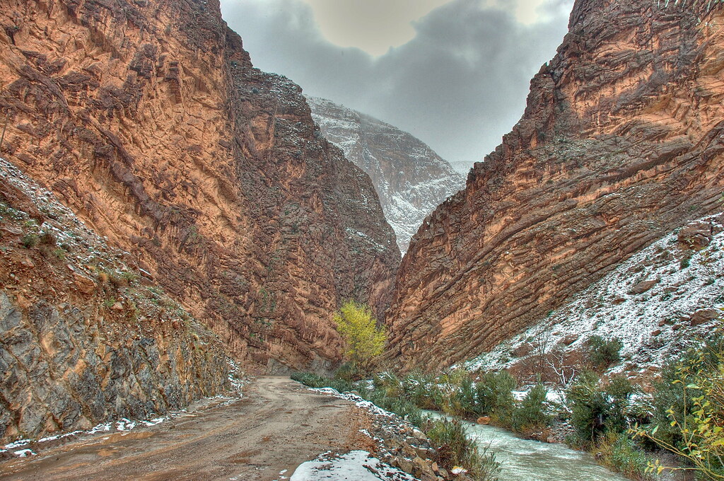
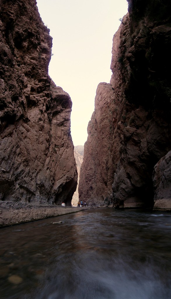
At Aït Oudinar, about one hour from Boumalne du Dades the nature changes dramatically. The mountain and the stones lose their red colour, and the valley narrows to a gorge. Most travellers turn around here, as the continuation will lead you through landscapes which are less unique than the Dades Valley and the road becomes hard to pass for normal cars.

There are a handful of small hotels and cafés here, so it makes a natural stop. And you can buy handicrafts, but most of these are not unique to Dades Valley.

With barren grey brown mountains and lush and fertile valleys, the continuation beyond Aït Oudinar is dramatic enough. The rough and winding roads will add much exitement to the total experience. At several points, you will be allowed a spectacular view over the valleys.

The main destination of this part of the trek is Msemrir, a rather non-descript place, but beyond this the road deteriorates and is not recommended for travelling without local guides.

It is possible to continue to great destinations like Imilchil and the Todra Gorge.

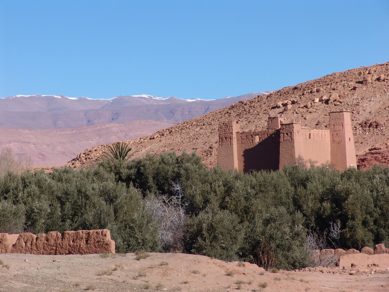
credited to flickr users: el gregein, staou, cathymiller, antonioperezrio.es, authenticmoroccoltd, nyctalope, marinegirl, arne kuilman, digs, michel27

Thursday, April 24, 2008

What Chicago Looks Like at Night, From 36,000 Feet

Chicago is a city in the state of Illinois and the largest in the Midwest. With a population of nearly 3 million people located almost entirely in Cook County (a portion of the city's O'Hare International Airport overlaps into DuPage County), Chicago is the third largest city in the United States. The population of Chicago's metropolitan area, which covers several counties (and commonly called Chicagoland), contains over 9.7 million people in Illinois, Wisconsin and Indiana, making it the third largest metropolitan area in the U.S. Adjacent to Lake Michigan, it is the largest city located on the Great Lakes and the world's twenty-second largest urban area by population. Chicago has been classified as an alpha world city for its worldwide economic influence.

credited to wikipedia and flickr user myelectricsheep

Wednesday, April 23, 2008

Russia's Radioactive mines

These guys have gone deep into old Soviet uranium mines. In these mines Russian prisoners have dug for radioactive materials for the Soviet Army.

As you can see on the top picture the Geiger counter shows that there is still some radioactive pollution.

credited to englishrussia.com

Tuesday, April 22, 2008

Lake Titicaca - Peru, Bolivia

Lake Titicaca is a lake located on the border of Bolivia and Peru. It sits 3,812 m (12,507 ft) above sea level making it the highest commercially navigable lake in the world. By volume of water it is also the largest lake in South America.

The lake is located at the northern end of the endorheic Altiplano basin high in the Andes on the border of Peru and Bolivia. The western part of the lake lies within the Puno Region of Peru, and the eastern side is located in the Bolivian La Paz Department.

The lake is composed of two nearly separate sub-basins that are connected by the Strait of Tiquina which is 800 m (2,620 ft) across at the narrowest point. The larger sub-basin, Lago Grande (also called Lago Chucuito) has a mean depth of 135 m (443 ft) and a maximum depth of 284 m (932 ft). The smaller sub-basin, Lago Huiñaimarca (also called Lago Pequeño) has a mean depth of 9 m (30 ft) and a maximum depth of 40 m (131 ft). The overall average depth of the lake is 107 m (351 ft).

Lake Titicaca is fed by rainfall and meltwater from glaciers on the sierras that abut the Altiplano. Five major river systems feed into Lake Titicaca—in order of their relative flow volumes these are: Ramis, Coata, Ilave, Huancané, and Suchez. More than 20 other smaller rivers empty into Titicaca, and the lake has 41 islands, some of which are densely populated.

Having only a single season of free circulation, the lake is monomictic and water passes through Lago Huiñaimarca and flows out the single outlet at the Rio Desaguadero, which then flows south through Bolivia to Lake Poopó. This only accounts for about 10% of the lake's water balance. Evapotranspiration, caused by strong winds and intense sunlight at altitude, balances the remaining 90% of the water input. It is nearly a closed lake.

The origin of the name Titicaca is unknown. It has been translated as "Rock Puma", allegedly because of its resemblance to the shape of a puma hunting a rabbit, combining words from the local languages Quechua and Aymara, and as well as translated as "Crag of Lead." Locally, the lake goes by several names. Because the southeast quarter of the lake is separate from the main body (connected only by the Strait of Tiquina), the Bolivians call it Lago Huiñaymarca (Quechua: Wiñay Marka) and the larger part Lago Chucuito. In Peru, these smaller and larger parts are referred to as Lago Pequeño and Lago Grande, respectively.

credited to wikipedia and flickr users: elisharenne, Jim Shannon, abmiller99, Phillie Casablanca, Diva wannabe2003, robduncan11, andy961, Sam Judson, stephenk1977, keatssycamore, toonsarah

Monday, April 21, 2008

Spectacular Sunset Over the Pacific Ocean

The Pacific Ocean is the largest of the Earth's oceanic divisions. It extends from the Arctic in the north to Antarctica in the south, bounded by Asia and Australia on the west and the Americas on the east. At 169.2 million square kilometers (65.3 million square miles) in area, this largest division of the World Ocean – and, in turn, the hydrosphere – covers about 46% of the Earth's water surface and about 32% of its total surface area, making it larger than all of the Earth's land area combined. The equator subdivides it into the North Pacific Ocean and South Pacific Ocean. The Mariana Trench in the western North Pacific is the deepest point in the Pacific and the world, reaching a depth of 10,911 metres (35,798 ft)

credited to wikipedia and NASA

Thursday, April 17, 2008

Ellesmere Island - Canada

Ellesmere Island is part of the Qikiqtaaluk Region of the Canadian territory of Nunavut. Lying within the Canadian Arctic Archipelago it is considered part of the Queen Elizabeth Islands, with Cape Columbia being the most northerly point of land in Canada. It comprises an area of 196,235 square kilometres (75,767 sq mi), making it the world's tenth largest island and Canada's third largest island. The Arctic Cordillera covers much of Ellesmere Island, making it the most mountainous in the Canadian Arctic Archipelago. The Arctic Willow is the only woody species to grow on Ellesmere Island.

More than one-fifth of the island is protected as Quttinirpaaq National Park (formerly Ellesmere Island National Park), which includes seven fjords and a variety of glaciers, as well as Lake Hazen, North America's largest lake north of the Arctic Circle. Barbeau Peak, the highest mountain in Nunavut (2,616 m (8,580 ft)) is located in the British Empire Range on Ellesmere Island. The most northern mountain range in the world, the Challenger Mountains, is located in the northeast region of the island. The northern lobe of the island is called Grant Land.

In July 2007, a study noted the disappearance of habitat for waterfowl, invertebrates, and algae on Ellesmere Island. According to John P. Smol of Queen's University in Kingston, Ontario, and Marianne S. V. Douglas of the University of Alberta in Edmonton, warming conditions and evaporation have caused low water levels changes in the chemistry of ponds and wetlands in the area. The researchers noted that "In the 1980s they often needed to wear hip waders to make their way to the ponds...while by 2006 the same areas were dry enough to burn.

credited to wikipedia and flickr users: j.slein, GristMill, russ-on-flickr, pfogal