 Langkawi sky-bridge in Malaysia is suspended at 700 metres above sea level. This unique curved pedestrian bridge spans 125 metres across a spectacular chasm. The view from the bridge is simply breathtaking. You'd be able to view the Andaman Sea and Thailand’s Tarutao Island as well.
Wednesday, January 30, 2008
Langkawi Sky Bridge
 Langkawi sky-bridge in Malaysia is suspended at 700 metres above sea level. This unique curved pedestrian bridge spans 125 metres across a spectacular chasm. The view from the bridge is simply breathtaking. You'd be able to view the Andaman Sea and Thailand’s Tarutao Island as well.
Posted by
Ivica Miskovic
at
11:34 AM
9
comments
![]()
Labels: Most Interesting Bridges
Monday, January 28, 2008
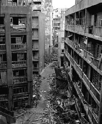
Ghost town - Hashima Island, Gunkanjima, Japan
 Hashima Island (meaning "Border Island"), commonly called Gunkanjima (meaning "Battleship Island") is one among 505 uninhabited islands in the Nagasaki Prefecture about 15 kilometers from Nagasaki itself. The island was populated from 1887 to 1974 as a coal mining facility. The island's most notable features are the abandoned concrete buildings and the sea wall surrounding it.
"Battleship Island" is an English translation of the Japanese nickname for Hashima Island, Gunkanjima. The island's nickname came from its apparent resemblance to a battleship, or gunkan (jima is a mutation of shima) due to its high sea-walls. It also is known as the Ghost Island. It is known for its coal mines and their operation during the industrialization of Japan. Mitsubishi bought the island in 1890 and began the project, the aim of which was retrieving coal from the bottom of the sea. They built Japan's first large concrete building, a block of apartments in 1916 to accommodate their burgeoning ranks of workers, and to protect against typhoon destruction.
In 1959, its population density was 835 people per hectare (83,500 people/km^2) for the whole island, or 1,391 per hectare (139,100 people/km^2) for the residential district, one of the highest population density ever recorded worldwide. As petroleum replaced coal in Japan in the 1960s, coal mines began shutting down all over the country, and Hashima's mines were no exception. Mitsubishi officially announced the closing of the mine in 1974, and today it is empty and bare, which is why it's called the Ghost Island. Travel to Hashima is currently prohibited.


Posted by
Ivica Miskovic
at
10:10 PM
11
comments
![]()
Labels: Ghost town's
Friday, January 25, 2008
Ghost town - Kadykchan, Russia
No, this isn’t Chernobyl and there isn’t any dangerous radioactive background or toxic pollution. You can even live in this town… but there is no reason for. This place has become absolutely useless after the collapse of the USSR, like many other Soviet industrial settlements.
Posted by
Ivica Miskovic
at
10:36 PM
3
comments
![]()
Labels: Ghost town's
Wednesday, January 23, 2008
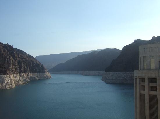
Megastructures - Hoover Dam
 History Construction of Hoover Dam began in 1931, and the last concrete was poured in 1935 , two years ahead of schedule. President Franklin D. Roosevelt dedicated the dam on September 30,1935. The power plant structures were completed in 1936, and the first generator began commercial operation in October of that year. The 17th and final generator went into commercial operation in 1961.
Hoover Dam was without precedent, the greatest dam constructed in its day. An arch-gravity structure rising 726 feet above bedrock, Hoover is still the Western Hemisphere's highest concrete dam. It is 660 feet thick at its base, 45 feet thick at its crest, and stretches 1,244 feet across the Black Canyon. There are 4.4 million cubic yards of concrete in the dam, power plant and related structures.
Hoover Dam pioneered the Bureau of Reclamation's efforts in multiple-purpose water resources development. The dam controls floods while it stores water for irrigation, municipal, and industrial uses. The dam also provides hydroelectric power generation, recreation and fish and wildlife habitat.
Dam Benefits
Colorado River water irrigates more than a million acres of land in the U.S., and nearly half a million acres in Mexico. The water helps meet the municipal and industrial needs of over 14 million people. As it passes through Hoover's turbines, the water generates low-cost hydroelectric power for use in Nevada, Arizona and California. About 4 billion kilowatt-hours of energy, enough for 500,000 homes, are generated annually:
Irrigation & Storage
Water that was once muddy is now sparkling clear in reservoirs and in stretches of the Colorado River. Hoover and other dams on the Colorado have tamed the turbulent flow, creating clean bodies of water that provide recreation for more than 10 million people each year. These waters have also provided habitats for fish and wildlife in areas that were once nearly barren.
By regulating the Colorado River, Hoover Dam assures a steady flow of municipal and industrial water to Los Angeles, San Diego and other cities in the Southwest. Phoenix, Arizona was added to the list when the Central Arizona Project began delivering water in 1985. The Tucson area began to receive project water in 1991. Several agriculture users, a number of smaller cities, and an Indian community between Phoenix and Tucson also benefit from the water availability.
Part of the hydroelectric energy generated at Hoover and Parker dams helps pump water along the Colorado River Aqueduct. The 242-mile-long aqueduct has an annual capacity of 1.212 million acre-feet (1 billion gallons) of water a day. Five pumping stations lift the water 1,617 feet over the mountains between the Colorado River and the coastal plain.
Homes and industries in the Las Vegas metropolitan area receive Colorado River water from Lake Mead through the Robert B. Griffith Water Project, which was completed in 1982.
Hydroelectric Power
Hydroelectric power is created as water rushes through turbines that activate generators. When the water has completed its task, it flows on unchanged to serve other needs. The electricity produced is clean, nonpolluting and, unlike many other forms of energy, renewable.
Vital Statistics
Hoover Dam
Height: 726.4 feet (221.28 meters)Crest Length: 1,244 feet(379.2 meters)
Top Thickness: 45 feet (13.7 meters)
Bottom Thickness: 660 feet (201.2 meters)
Composition: 3.25 million cubic yards
(2.5 million cubic meters) of concrete.
The Reservoir (Lake Mead)
Length: When full 110 milesShoreline: 550 miles
Capacity: 28,537,000 acre-feet , including dead storage
Maximum depth: 500 feet
Area: 157,900 acres
Elevation: 1221.4 feet


Posted by
Ivica Miskovic
at
9:20 PM
2
comments
![]()
Labels: Megastructures
Tuesday, January 22, 2008
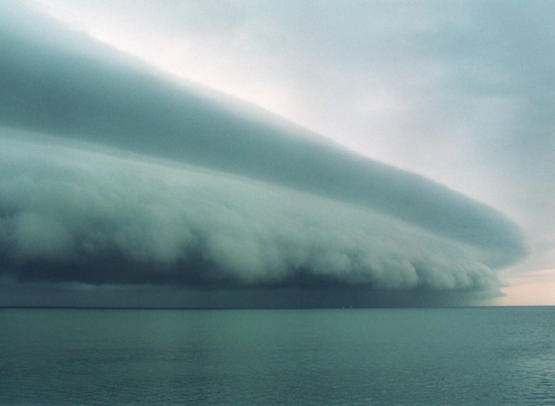
Ships in storm


Posted by
Ivica Miskovic
at
10:41 PM
3
comments
![]()
Labels: Weather
Wednesday, January 16, 2008
World's most Interesting Bridges
1. The Piazza di San Marco - Venice
The Piazza di San Marco may be more famous, but the Ponte di Rialto (Rialto Bridge) is the true heart of Venice. The current structure was built in just three years, between 1588 and 1591, as a permanent replacement for the boat bridge and three wooden bridges that had spanned the Grand Canal at various times since the 12th Century. It remained the only way to cross the Grand Canal on foot until the Accademia Bridge was built in 1854.
The Rialto Bridge's 24-foot arch was designed to allow passage of galleys, and the massive structure was built on some 12,000 wooden pilings that still support the bridge more than 400 years later. The architect, Antonio da Ponte ("Anthony of the Bridge," appropriately enough), competed against such eminent designers as Michelangelo and Palladio for the contract.
The bridge has three walkways: two along the outer balustrades, and a wider central walkway leading between two rows of small shops that sell jewelry, linens, Murano glass, and other items for the tourist trade. (NOTE: The bridge consists primarily of steps, making it a challenge for tourists with strollers or wheelchairs.)
2. Stari Most (The Old Bridge) - Mostar
Stari Most (English translation: "The Old Bridge") is a 16th century Turkish bridge in the city of Mostar, Bosnia and Herzegovina that crosses the river Neretva and connects two parts of the city. The bridge was destroyed by Croatian Council of Defence units during the War in Bosnia-Herzegovina, on November 9, 1993 at 10.15 am. A project was set in motion to rebuild it, and the new bridge built by Turkish masters opened on July 23, 2004.
The bridge spans the Neretva river in the old town of Mostar, the city to which it gave the name. The city is the fourth-largest in the country, it is the center of the Herzegovina-Neretva Canton of the Federation, and the unofficial capital of Herzegovina.
The Stari Most is hump-backed, 4 meters wide and 30 meters long, and dominates the river from a height of 24 meters. Two fortified towers protect it: the Helebija tower on the northeast and the Tara tower on the southwest, called "the bridge keepers" (natively mostari).
The arch of the bridge was made of local stone known as tenelija. The shape of the arch is the result of numerous irregularities produced by the deformation of the intrados (the inner line of the arch). The most accurate description would be that it is a circle of which the centre is depressed in relation to the string course.
Instead of foundations, the bridge has abutments of limestone linked to wing walls along the waterside cliffs. Measuring from the summer water level of 40.05 m, abutments are erected to a height of 6.53 m, from which the arch springs to its high point. The start of the arch is emphasized by a moulding 0.32 m. in height. The rise of the arch is 12.02 m.
3. Gateshead Millennium Bridge - England
Designed by Wilkinson Eyre Architects and engineered by Gifford, the bridge takes its place at the end of a line of distinguished bridges across the River Tyne, including the Tyne Bridge and Robert Stephenson's High Level Bridge.
Linking Gateshead with Newcastle via Gateshead Quays (described as one of the best places in Europe by Tony Blair) and Newcastle’s Quayside, the bridge not only serves a functional purpose as the River Tyne’s only foot and cycle bridge, but its grace and engineering attract people from all over the world.
In 1996 Gateshead Council launched a competition to find a bridge that would link developments on both sides of the River Tyne and also complement the existing six bridges crossing the river.
There were over 150 entries. Gateshead residents voted for their favourite design from a shortlist of leading architectural companies.
-Allowed ships to pass underneath;
-Did not overshadow the world famous view of the existing bridges;
-Didn’t obstruct the Quayside.
The winning design by Wilkinson & Eyre Architects and Gifford & Partners met the criteria perfectly. Everyone knew this design was exceptional.
Leader of Gateshead Council, Councillor Mick Henry said:
"When we chose the design for the Gateshead Millennium Bridge, we knew we had something very special. The many awards and accolades it has received for its design and construction, has certainly proved us right. But even though we knew how innovative it was, we have been taken aback by the massive worldwide interest in our bridge.
"Local people have taken the bridge to their hearts as a symbol of Gateshead’s renaissance, and we are thrilled that the bridge now looks set to appear on a pound coin in the near future.
"But we are equally flattered that people right around the world are interested in what we have done, and will continue to do, in order to regenerate Gateshead Quays and East Gateshead."
4. The Longest Arch Bridge - Lupu Bridge - China
The Lupu Bridge is currently the longest arch bridge in the world, stretching a massive 550 meters across the Huangpu River, China. Along with being a record holder ("The bridge's arch is longer than the previous record holder, the 518-metre long New River Gorge Bridge in West Virginia"), the bridge is also the center point for a lot of local hostility.
The need for a bridging between the Luwan District on the north bank, and Pudong New District on the south bank was agreed by all, but that was where the agreement stopped. The exorbitant cost of the Lupu Bridge was frowned upon by locals and scholars, but chosen by the disgraced mayor Chen Liangyu as it would set the area apart with a world record bridge. The critics use this bridge as an argument to prove the city officials superficiality, when weighed against the needs of its people.
5. Hangzhou Bay Bridge - China
Hangzhou Bay Bridge , is a cable-stayed bridge across Hangzhou Bay off the eastern coast of China. It was linked up on June 14, 2007, and connects the municipalities of Shanghai and Ningbo in Zhejiang province. The bridge is the longest trans-oceanic bridge in the world, although it does not have the longest cable-stayed main span. The opening ceremony was held on June 26, 2007 with great domestic media publicity, though after the opening ceremony, the bridge would only be used for test and evaluation purposes. It will not be available to ordinary public transportation, which is scheduled sometime in 2008.
Construction of this bridge started on June 8, 2003. The bridge itself is 36 km long with six expressway lanes in two directions, making it the second-longest bridge in the world after the Lake Pontchartrain Causeway in Louisiana, USA. The bridge has two main spans, with a 448 metre northern span, and a 318 metre southern span. The designated speed is 100 kilometers per hour, and the designed longevity is more than 100 years. The total investment on the bridge is RMB 11.8 billion (US$ 1.4 billion as of December 2004). 35% of this amount was raised from private companies in Ningbo, 59% was provided as loans from China's central and regional banks. Orthotropic steel deck is used on its main spans and five ramp bridges, and is to be paved with 50 mm epoxy asphalt concrete.
6. The Kawazu-Nanadaru Loop Bridge
Many innovations seem only to appear where there is a really unusual need, warranting an unusual solution. The Kawazu-Nanadaru Loop Bridge in Japan is one such example: How do you build a bridge from one mountainside to another when the sides of the mountain are so steep that it is not possible to build a road at the same elevation on both sides? This double spiral brings cars up and down a full 45 meters (148 feet) while being seemingly suspended in a valley between two mountainsides.
- 1.1 km long
- 80 meters in diameter
- speed limit: 30 km/h
Coming upon this bridge in the middle of this mountain road is quite an experience. The bridge was finished in 1982 and has become a popular landmark on route 414 heading south from Tokyo towards the hot spring resorts of the Izu peninsula. If you know of any other bridges like this in the world, please let me know via the comments below.
Posted by
Ivica Miskovic
at
2:34 PM
0
comments
![]()
Labels: Most Interesting Bridges


